Tongoni Ruins
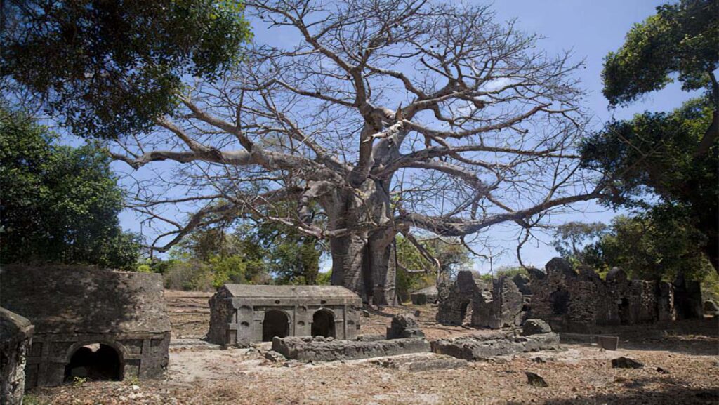
The Tanga-Pangani route passes the Tongoni Ruins, which are located 21 kilometers south of Tanga City. Baobab trees and a mangrove forest border the Indian Ocean, which provides a picturesque backdrop for the ruins. Among the many well-known artifacts from the Shirazi civilization, which flourished along East Africa’s Indian Ocean coast, are the Tongani ruins. The Tongoni Ruins, which show the Shirazi civilization, are thought to have been one of the earliest Shirazi villages. Historic cemeteries, mosque ruins, and the East African Coast’s largest collection of 20 overgrown Shirazi pillar-style tombs are among the area’s highlights. An estimated date of construction for the mosque and tombs is the fourteenth or fifteenth century. Just beyond the ruins lies a fishing town where you can witness the cultural and traditional practices of some of the Shirazi people’s descendants.
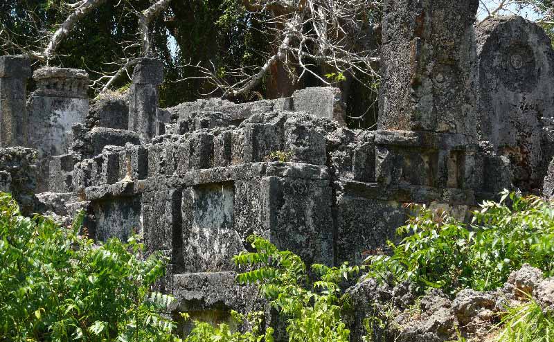
An ancient Swahili mosque and forty graves dating back to the 15th century can be found in Tongoni ward, Tanga District, Tanga Region, Tanzania. The ruins are known as Magofu ya kale ya Tongoni in Swahili.
Tongoni, situated 25 kilometers north of the Pangani River, is Tanzania’s biggest and arguably most important Swahili site. A third of an acre is devoted to a Friday Mosque in the northern style and approximately forty standing graves overlooking Mtangata Bay.
Locals still hold spiritual services there. They lay their loved ones to rest just south of the ancient graves. There was a significant change to the landscape between 400 and 500 years ago. In the 15th century, it was a thriving and esteemed Swahili commerce hub, in stark contrast to its largely forgotten status now.
Kilole Bay, situated almost 40 kilometers north of Muhembo, features the Tongoni Ruins atop a low embankment along the bay’s southwest edge.
The bay is shielded by peninsulas from vigorous monsoon winds. The shoreline of the area is populated with mangroves. Tongoni, the village of Mtangata, has approximately 3,500 residents, predominantly engaged in cassava and coconut farming as well as fishing, and is encircled by dispersed trees, including baobabs, tamarinds, and palms. Sandy soils are predominant around the bay, especially in Vumbani in the southeastern region of Mtangata.
The littoral features a limestone substrate overlaid by loams and clay loams. Situated on a Pleistocene terrace that commands a view of Mtangata and the ocean.
To the east, the expansive countryside inhabitants, comprising individuals who identify as Zigua, Digo, and Nyamwezi (the latter being new arrivals), cultivate maize and vegetables and collect firewood. This coastline is interspersed by freshwater wells, several of which have recently turned saline. To the north lies the village of Sadani.
Archaeological discoveries Significant findings were obtained in shovel test pits. The researchers discovered other items to the north, south, and west of the ancient mosque. Local vessels exhibit characteristic Swahili decoration, including punctures or stamped dots along or beneath their necks.
Furthermore, a STP situated west of the mosque yielded a fragment of gneiss grindstone, a raw material exclusively located in mountainous regions. Between Mtangata and Vumbani, the lateral surface is adorned with numerous beads and some coins from the late eighteenth century. At Vumbani, a subsurface examination revealed fragments of Indian pottery, Chinese celadon, blue-green Islamic monochrome, and coiled and drawn glass beads.
Researchers have recorded around 7,000 locally manufactured ceramics in Tongoni, of which 10.7% are classified as diagnostic. The complete assembly is most well illustrated by Unit 3 of the site. There are a total of 328 diagnostics, comprising 4 undecorated bases, 98 decorated body sherds, 115 ornamented rims, and 112 undecorated rims. Local ceramics generally exhibit a surface coloration that varies from brown to black, with some cases of orange. Cores possess a coarser texture and are generally dark in color, including shades of brown, black, or gray. Ceramic ingredients comprise 2–4% quartz temper.
Furthermore, the gang collected beads and exotic ceramics. The latter constitutes around 1.2% of the excavated sherds. The place features several types, predominantly blue-green Islamic monochromes and other Middle Eastern varieties. Chinese celadons and blue-and-white ceramics are also extensively utilized. These pottery variants were created from the fourteenth to the seventeenth century. Furthermore, the upper layers have a limited quantity of European potteries dating from the late 18th to early 19th centuries.
Among the notable discoveries are an atypical stone of indeterminate material, two polished sharpening stones, a collection of coral fragments partially surrounding an ash pit, substantial local sherds (many adorned), one blue glass bead, one faceted carnelian tube bead, and an oyster nut seed. The researchers also uncovered a small carving of a human visage on the jaw of a parrotfish (Family Scaridae) and a bone hairpin.
An ash lens, multiple large shells including conchs, a gneiss grinding stone, a grinding or sharpening stone with an unidentified red stain, a substantial piece of slag, a cow vertebra, six glass beads, one ivory bead, and two oyster nut seeds. The inhabitants of Mtangata collectively determined that such findings belonged to a healer or other esteemed members of the community. The sculpted visage, the multifaceted carnelian bead historically donned by Zigua healers, and the oyster nut seeds all possess compelling significances.